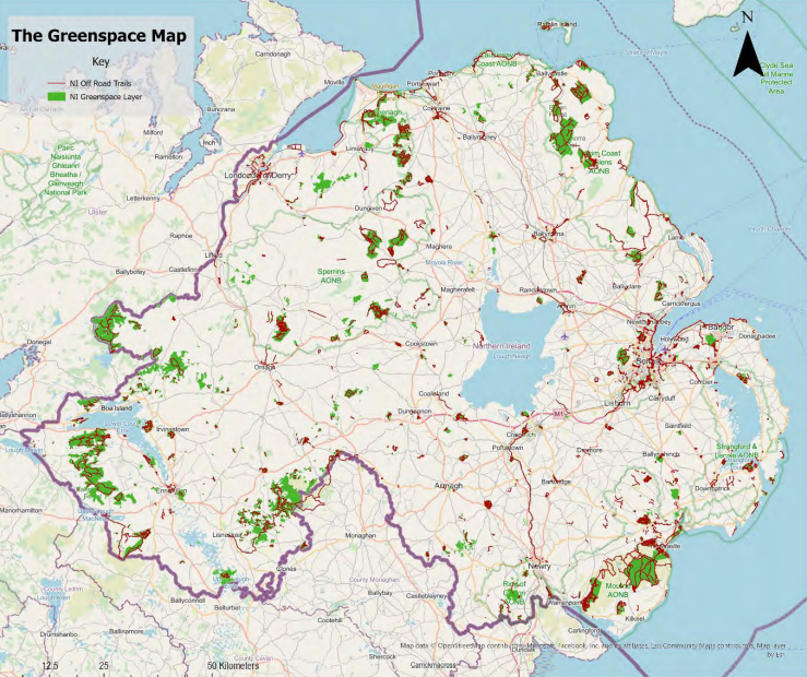
- A map shared on Twitter claims to show all the greenspace in Northern Ireland currently available to the public.
- The GreenspaceNI map is a work in progress, and currently only features green areas at least two hectares in size.
- As things stand, the map – compiled from a host of sources – is the best-available representation of public-accessible natural space in NI.
On 25 May, Irish Mirror/Belfast Live Environment Correspondent Shauna Corr shared the following image on Twitter:
In her tweet, she said:
“This map of Northern Ireland shows the amount of green space available to the public – not a lot, is it”
Is this right? Yes – but with some useful context.
The image shows the GreenspaceNI map. The map is a work in progress. It has been created by a local non-profit organisation, with funding from various Stormont departments.
It relies on information from a wide range of sources and only includes natural spaces that are at least two hectares (ha) in size – with plans to lower this limit to 0.5ha in future.
However, the map is a visual representation of the best data currently available on all of NI’s public natural spaces.
- Source
The map comes from a May 2023 report from the Northern Ireland Statistics and Research Agency (NISRA), co-produced with the Department of Agriculture, Environment and Rural Affairs (DAERA) and the Northern Ireland Environment Agency (NIEA).
On page 13 of the Northern Ireland Environmental Statistics Report is a section titled Accessible Natural Space. It features an image of the map above, which it says is sourced from Outdoor Recreation NI.
According to NISRA:
“[The map] is a collated Northern Ireland-wide map of all accessible natural space over two hectares and off-road routes. It includes natural spaces and trails where the public have the landowner’s permission to visit, such as in urban and country parks, forests, beaches and walking trails.”
Outdoor Recreation NI is a non-profit organisation aiming to improve access to outdoor spaces. The organisation says it received funding from DAERA and the Department for Infrastructure (DfI) “to create a map of all greenspace and off-road trail assets with public access in Northern Ireland.”
- Methodology
So, to be included on this map, any natural space has to be at least two hectares (ha) in size. One hectare is 10,000m2, so two hectares is 20,000m2 – or around three football pitches.
There is a practical reason for this. The map is still under development. Outdoor Recreation NI has produced its own “story map” describing how the GreenspaceNI map was built and how it can be used. The organisation wants future iterations of this map to include more data, including publicly-accessible greenspaces that are 0.5ha or larger.
The current version was produced in May 2023, and the plan is to annually update the map – although changes could happen more regularly than that (and any links in this article to the live map could show some small differences from the map in the image above and the original tweet). Outdoor Recreation NI publishes its own set of disclaimers around the accuracy and usability of the map, noting that “[best] efforts have been made… to ensure the accuracy of the data.”
The map currently shows green spaces (in green) and off-road trails (purple). To feature on the map, greenspaces must be above the minimum size, they must be “an area of natural green space” (although they may feature some non-natural land), and they must be open and accessible to the public (although, according to the NISRA report, “in some cases there may be restricted access”). Trails must be off road, and have public access.
Datasets from 20 different organisations were used to build the map, including NI’s eleven local councils, various Stormont departments, and several organisations focused on natural spaces, such as the Woodland Trust, Forest Service and Ulster Wildlife.
- Comparisons
Outdoor Recreation NI is currently developing its map of natural spaces in Northern Ireland. The organisation says that, unlike the rest of the UK, there is no authoritative local map that documents all publicly accessible greenspace and off-trails.
“England, Scotland and Wales have this in the form of Ordnance Survey GB Greenspace Open Layer and MasterMap Greenspace Layer, and the Republic of Ireland is currently developing an online Base Registry of Sports and Recreation Amenities. In GB, the OS MasterMap Greenspace is also starting to be used by governments to monitor the ‘% of homes with greenspace within a 5-minute walk from home’ target using network routing analysis.”
The current map for NI is being used for this sort of analysis already, albeit with a smaller dataset than it aims to have in future.
According to current data, the map contains 96,470ha of publicly accessible greenspace – plus Plus 2,926 miles of off-road trails – with that greenspace split into five categories:
- Woodland – 70,040ha
- Parks and Gardens – 16,034ha
- Open Country – 6,019ha
- Amenity Greenspace – 2,265ha
- Nature Reserves – 2,115ha
Using the current data, analysis shows that:
- 50% of NI households are within 400m of a greenspace (>2ha) or off-road trail.
- 75% are within 1km of a greenspace (>2ha) or off-road trail.
- 83% are within 2km of a greenspace (>2ha) or off-road trail.
Remembering that the greenspace needs to be open to the public, according to Outdoor Recreation NI:
“Further analysis reveals that 59% of households within urban areas are within 400m of greenspace or trails, whereas this falls to 10% of households within rural areas.”